Village and civil parish in England
| West Markham | |
|---|---|
| Village and civil parish | |
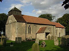
 All Saints' Church All Saints' Church | |
| Parish map | |
 | |
| Area | 1.73 sq mi (4.5 km) |
| Population | 175 (2021) |
| • Density | 101/sq mi (39/km) |
| OS grid reference | SK721727 |
| • London | 125 mi (201 km) SSE |
| Civil parish |
|
| District | |
| Shire county | |
| Region | |
| Country | England |
| Sovereign state | United Kingdom |
| Post town | Newark |
| Postcode district | NG22 |
| Dialling code | 01777 |
| Police | Nottinghamshire |
| Fire | Nottinghamshire |
| Ambulance | East Midlands |
| UK Parliament | |
| Website | markhamclinton |
| |
West Markham or Markham Clinton is a village and civil parish 23 miles (37 km) north east of Nottingham, in the Bassetlaw district, in the county of Nottinghamshire, England. In the 2011 census, the parish had a population of 170, and this increased marginally to 175 residents at the 2021 census. The parish touches Bevercotes, West Drayton, East Markham, Bothamsall, Walesby and Tuxford. The A1 previously went through the village but its now been bypassed.
Features
There are 4 listed buildings in West Markham. West Markham has a church called All Saints' Church.
History
The name "Markham" means 'Boundary homestead/village'. The name "Clinton" comes from the family name of the earls of Lincoln. Markham Clinton was recorded in the Domesday Book as Westmarcham. The medieval village of West Markham is now unoccupied but still has earthworks. On 1 April 1935 a part of Tuxford parish was transferred to the parish. The transferred area was 46 acres. The village has also been called Parva Markham and Little Markham.
References
- ^ "Markham Clinton". GENUKI. Retrieved 5 July 2019.
- "Distance from Markham Clinton [53.246432, -0.920961]". GENUKI. Retrieved 5 July 2019.
- UK Census (2011). "Local Area Report – West Markham Parish (E04007851)". Nomis. Office for National Statistics. Retrieved 5 July 2019.
- UK Census (2021). "2021 Census Area Profile – West Markham parish (E04007851)". Nomis. Office for National Statistics. Retrieved 25 January 2024.
- "West Markham". Ordnance Survey. Retrieved 5 July 2019.
- "Listed Buildings in West Markham, Bassetlaw, Nottinghamshire". British Listed Buildings. Retrieved 5 July 2019.
- Historic England, "All Saints Church (322880)", Research records (formerly PastScape), retrieved 5 July 2019
- "Markham Clinton Key to English Place-names". The University of Nottingham. Retrieved 5 July 2019.
- "Nottinghamshire F-R". The Domesday Book Online. Retrieved 5 July 2019.
- Historic England, "West Markham (1146154)", Research records (formerly PastScape), retrieved 5 July 2019
- "Relationships and Changes Markham Clinton Or West Markham CP/AP through time". A Vision of Britain through Time. Retrieved 5 July 2019.
- "West Markham - History". Southwell Churches. Retrieved 5 July 2019.
External links
- "West Markham". British History Online. Retrieved 5 July 2019.
- YouTube video - parish visit journal
| Ceremonial county of Nottinghamshire | |
|---|---|
| Unitary authorities | Nottingham |
| Boroughs or districts | |
| Major settlements (cities in italics) |
|
| Topics | |