| Wilton Mountain | |
|---|---|
 Wilton Mountain, Le Flore county, Oklahoma. Wilton Mountain, Le Flore county, Oklahoma. | |
| Highest point | |
| Elevation | 2,543 ft (775 m) |
| Coordinates | 34°40′42″N 94°34′1″W / 34.67833°N 94.56694°W / 34.67833; -94.56694 |
| Geography | |
 | |
| Location | Le Flore County, Oklahoma, United States |
| Topo map(s) | USGS Page, OK |
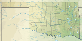
Wilton Mountain, in Ouachita National Forest, is a summit in the Ouachita Mountains in Le Flore County, Oklahoma, approximately 2 miles (3 km) from U.S. Route 59 and approximately 6 miles (10 km) west of the Arkansas state line. Wilton Mountain is 2,543 feet (775.1 m) above mean sea level.
References
- "Wilton Mountain". Geographic Names Information System. United States Geological Survey, United States Department of the Interior. Retrieved May 4, 2009.
| Mountains of Oklahoma | |||||
|---|---|---|---|---|---|
| Ouachita Mountains |
| ||||
| Wichita Mountains | |||||
| Others | |||||
This Oklahoma state location article is a stub. You can help Misplaced Pages by expanding it. |