| Winnemucca Municipal Airport (Franklin Field) | |||||||||||||||
|---|---|---|---|---|---|---|---|---|---|---|---|---|---|---|---|
 Airport entrance Airport entrance | |||||||||||||||
| Summary | |||||||||||||||
| Airport type | Public | ||||||||||||||
| Owner | City/County | ||||||||||||||
| Serves | Winnemucca, Nevada | ||||||||||||||
| Location | Humboldt County, Nevada | ||||||||||||||
| Elevation AMSL | 4,308 ft / 1,313 m | ||||||||||||||
| Coordinates | 40°53′48″N 117°48′21″W / 40.89667°N 117.80583°W / 40.89667; -117.80583 | ||||||||||||||
| Maps | |||||||||||||||
 | |||||||||||||||
 | |||||||||||||||
| Runways | |||||||||||||||
| |||||||||||||||
| Helipads | |||||||||||||||
| |||||||||||||||
| Statistics (2022) | |||||||||||||||
| |||||||||||||||
| Source: Federal Aviation Administration | |||||||||||||||
Winnemucca Municipal Airport (IATA: WMC, ICAO: KWMC, FAA LID: WMC) is six miles southwest of Winnemucca, in Humboldt County, Nevada. The airport was renamed Franklin Field on April 20, 2019, in honor of Lt. Col. Irl “Leon” Franklin, a decorated Vietnam War veteran and combat pilot who earned the Silver Star for his lead role in Operation Ivory Coast.
The National Plan of Integrated Airport Systems for 2011–2015 categorized it as a general aviation facility.
Facilities
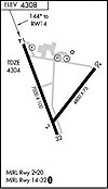
The airport covers 968 acres (392 ha) at an elevation of 4,308 feet (1,313 m). It has two asphalt runways: 14/32 is 7,000 by 100 feet (2,134 x 30 m) and 2/20 is 4,800 by 75 feet (1,463 x 23 m). It has two concrete helipads (H1 and H2) each 25 by 25 feet (8 x 8 m).
In the year ending September 28, 2022 the airport had 6,925 aircraft operations, average 133 per week: 68% general aviation, 26% air taxi, and 5% military. 14 aircraft were then based at this airport: 10 single-engine and 4 ultra-light.
See also
References
- ^ FAA Airport Form 5010 for WMC PDF. Federal Aviation Administration. Effective July 13, 2023.
- "IATA Airport Code Search (WMC: Winnemucca)". International Air Transport Association. Retrieved June 14, 2014.
External links
 Media related to Winnemucca Municipal Airport at Wikimedia Commons
- "Diagram of Winnemucca Municipal Airport (WMC)" (PDF). from Nevada DOT
- Aerial image as of June 1994 from USGS The National Map
- FAA Terminal Procedures for WMC, effective December 26, 2024
- Resources for this airport:
- FAA airport information for WMC
- AirNav airport information for KWMC
- ASN accident history for WMC
- FlightAware airport information and live flight tracker
- NOAA/NWS weather observations: current, past three days
- SkyVector aeronautical chart, Terminal Procedures
This Nevada airport-related article is a stub. You can help Misplaced Pages by expanding it. |