Unincorporated community in Louisiana, United States
| Yscloskey Habitación (Spanish) | |
|---|---|
| Unincorporated community | |
 View of the lift bridge across Bayou la Loutre. View of the lift bridge across Bayou la Loutre. | |
  | |
| Coordinates: 29°50′31″N 89°41′18″W / 29.84194°N 89.68833°W / 29.84194; -89.68833 | |
| Country | |
| State | |
| Parish | |
| MCD | District E |
| Historic colonies | Louisiana (New Spain) Louisiana (New France) |
| Established | 1783 |
| Elevation | 0.9 m (3 ft) |
| Demonym(s) | waikloskero, -ra; güaiclosquero, -ra |
| Time zone | UTC−6 (Central) |
| • Summer (DST) | UTC−5 (Central) |
| ZIP code | 70085 |
| Area code | 504 |
| GNIS feature ID | 1628547 |
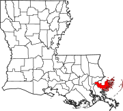
Yscloskey (IPA: /waɪˈklɒski/ wy-KLOSK-ee), also commonly known as Habitación (IPA: [aβitaˈsjon] ) in Spanish, is an Isleño fishing community in St. Bernard Parish, Louisiana, United States. The community is located near the coast of Lake Borgne on the northeastern bank of Bayou la Loutre and along both sides of Bayou Yscloskey. Following the American Civil War, the community was founded by Isleño hunters, trappers, and fisherman.
Yscloskey is connected to the rest of St. Bernard Parish by the Bayou la Loutre lift bridge, also known as the Yscloskey bridge. The Louisiana Department of Transportation and Development considers the bridge eligible for the National Register of Historic Places. Yscloskey Hwy, a continuation of Louisiana Highway 46, travels through the eastern half of the community as well as Shell Beach.
References
- "Yscloskey". Geographic Names Information System. United States Geological Survey, United States Department of the Interior. Retrieved August 29, 2021.
- Armistead, Samuel G. (1994). "Un topónimo guanche en Luisiana". Philologica Canariensia (in Spanish). Las Palmas de Gran Canaria: Facultad de Filología de la Universidad de Las Palmas de Gran Canaria. ISSN 1136-3169.
- Hyland, William de Marigny. "Los Isleños – A Historic Overview". Los Isleños Heritage and Cultural Society of St. Bernard. Retrieved May 27, 2020.
- ^ Broach, Drew (August 7, 2015). "29 historic bridges of southeast Louisiana". NOLA.com. The Times-Picayune. Retrieved September 15, 2021.
- Parker, Halle (August 31, 2021). "Destroyed by Hurricane Katrina, St. Bernard Parish fares much better than others in Ida". NOLA.com. Retrieved September 15, 2021.
| Municipalities and communities of St. Bernard Parish, Louisiana, United States | ||
|---|---|---|
| Parish seat: Chalmette | ||
| CDPs |  | |
| Other communities | ||
| Ghost towns | ||
This Louisiana state location article is a stub. You can help Misplaced Pages by expanding it. |