| Forks of the Credit Provincial Park | |
|---|---|
| IUCN category II (national park) | |
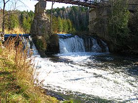
 Credit River flowing through Forks of the Credit Provincial Park Credit River flowing through Forks of the Credit Provincial Park | |
 | |
| Location | Ontario, Canada |
| Nearest city | Caledon, Ontario |
| Coordinates | 43°48′58″N 80°00′43″W / 43.816°N 80.012°W / 43.816; -80.012 |
| Area | 282 hectares (700 acres) |
| Established | 1985 |
| Visitors | 51,559 (in 2022) |
| Governing body | Ontario Parks |
| Website | ontarioparks |
Forks of the Credit Provincial Park, located in Caledon, Ontario, Canada, is part of the Ontario Parks system and is part of the Niagara Escarpment biosphere. The park is on the Bruce Trail. The Credit River runs through the park. Other notable features of the park include a kettle lake and talus slope.
History
In 1968 the Niagara Escarpment Study recommended that a park be established in the Forks of the Credit area; this recommendation was then accepted by the Government of Ontario. It was officially regulated as a provincial park in 1985.
Historic mill and dam
There has been a mill in the area since 1820. In 1885, John Deagle bought the mill at the top of the falls and converted it into an electrical generating station, damming the river and creating Cataract Lake; he named the enterprise The Cataract Electric Co. Ltd. Later the station was purchased by Ontario Hydro and was eventually shut down in 1947. The dam was later destroyed and the lake drained. The ruins of the mill and powerhouse are located within the park; The ruins of the Deagle mill are the most visible reminders of the history.
Bailey Bridge
In 1999 the Canadian 2nd Engineering Regiment (32 Combat Engineer Regiment) built a pedestrian Bailey Bridge along Meadow Trail and refurbished with new decking in 2016.
Railway station
The Credit Valley Railway reached the area in 1879 and built a station at the Forks of the Credit as well as a timber trestle spanning the Credit River. The primary purpose was shipping Credit Valley sandstone to other communities in Ontario, particularly Toronto and Hamilton, where the product was used in the construction of large buildings such as Queen's Park and the original Toronto City Hall. No remnants of the station remain.
References
- UNEP-WCMC. "Protected Area Profile for Forks of the Credit Provincial Park". World Database on Protected Areas. Retrieved 2024-11-02.
- Roots, Betty Ida (2000-05-01). Special places: the changing ecosystems of the Toronto region. UBC Press. p. 275. ISBN 978-0-7748-0736-4. Retrieved 6 March 2012.
- Parks, Ontario. "Ontario_Parks-Visitation-Statistics 2022 - Ministries". data.ontario.ca. Retrieved 2024-11-02.
- Wake, Winifred Cairns; Naturalists, Federation of Ontario (1997-06-14). A nature guide to Ontario. University of Toronto Press. p. 115. ISBN 978-0-8020-2755-9. Retrieved 17 November 2010.
- ^ "Forks of the Credit Provincial Park Management Plan". www.ontario.ca. Retrieved 12 February 2017.
- ^ "Forks of the Credit Park combines hiking & history". erininsight.blogspot.ca. Retrieved 12 February 2017.
- "Landscape Inventory Report page 7-30" (PDF). 1 March 2016. Archived from the original (PDF) on 27 February 2019. Retrieved 26 February 2019.
The actual closing of the plant in 1947 by Ontario Hydro led eventually to the dynamiting of the dam at 'Cataract Lake' and the disappearance of this man-made feature, which had become a part of area life. The ruins of Deagle's mill are the most visible remnant of the historic period of water-powered milling on this section of the Credit River and of Deagle's pioneering work in hydro-electric generation.
- https://www.waymarking.com/waymarks/WMY941_Credit_River_Bailey_Bridge_Forks_Of_The_Credit_Park_Caledon_Ontario
- "Landscape Inventory Report page 7-31" (PDF). 1 March 2016. Archived from the original (PDF) on 27 February 2019. Retrieved 26 February 2019.
With the rail link in place, Credit Valley sandstone was shipped throughout southern Ontario but primarily to Toronto and Hamilton. Queen's Park and the old Toronto City Hall are two significant examples of the many important buildings completed in this material. Four varieties of 'dimension' sandstone were available from the Forks' quarries: a grey with occasional brown spots; a uniform grey stone of particularly high quality; a brownstone which varied from chocolate to deep brown depending on the quarry with occasional deposits of a pinkish brown stone (particularly prized) and a piebald mix of white and brown stone.
