Commune in Occitania, France
| Lecques | |
|---|---|
| Commune | |
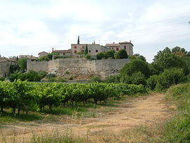
 View of Lecques from the south View of Lecques from the south | |
| Location of Lecques | |
  | |
| Coordinates: 43°50′16″N 4°03′50″E / 43.8378°N 4.0639°E / 43.8378; 4.0639 | |
| Country | France |
| Region | Occitania |
| Department | Gard |
| Arrondissement | Nîmes |
| Canton | Calvisson |
| Intercommunality | Pays de Sommières |
| Government | |
| • Mayor (2020–2026) | Bernadette Poher |
| Area | 5.2 km (2.0 sq mi) |
| Population | 473 |
| • Density | 91/km (240/sq mi) |
| Time zone | UTC+01:00 (CET) |
| • Summer (DST) | UTC+02:00 (CEST) |
| INSEE/Postal code | 30144 /30250 |
| Elevation | 26–111 m (85–364 ft) (avg. 50 m or 160 ft) |
| French Land Register data, which excludes lakes, ponds, glaciers > 1 km (0.386 sq mi or 247 acres) and river estuaries. | |
Lecques (French pronunciation: [lɛk]; Occitan: Lècas) is a commune in the Gard department in southern France.
It is built on rising ground, on the west bank of the River Vidourle, 6 km (3.7 mi) to the north and upstream of Sommières. The village centre is on a rocky outcrop that overhangs the bank of the river. Steps lead down to the bridge. Its elevation means it is protected from the 'vidourlades' or violent floods, for example, that of 9 September 2002. There are remains of the ramparts, the narrow medieval streets and a church.
Etymology
The name 'Lecques' comes from the Celtic word 'leucas', meaning a settlement by a marker post on an ancient track.
Population
| This section does not cite any sources. Please help improve this section by adding citations to reliable sources. Unsourced material may be challenged and removed. (October 2021) (Learn how and when to remove this message) |
| Year | Pop. | ±% |
|---|---|---|
| 1962 | 191 | — |
| 1968 | 203 | +6.3% |
| 1975 | 165 | −18.7% |
| 1982 | 182 | +10.3% |
| 1990 | 215 | +18.1% |
| 1999 | 216 | +0.5% |
| 2008 | 371 | +71.8% |
-
The bridge and River Vidourle
-
The church in the village
-
Steps from village to river, with markers of flood levels
-
Swimming in the river
See also
References
- "Répertoire national des élus: les maires" (in French). data.gouv.fr, Plateforme ouverte des données publiques françaises. 4 May 2022.
- "Populations de référence 2022" (in French). The National Institute of Statistics and Economic Studies. 19 December 2024.
- ^ Interpretation board erected by the Intercommunality
- Interpretation board erected by the Syndicat interdepartmental d'Aménagement du Vidoule
This Gard geographical article is a stub. You can help Misplaced Pages by expanding it. |