| Schoemanshoek | |
|---|---|
| Village | |
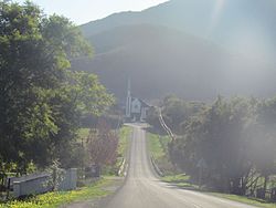
 The Dutch Reformed Church of Schoemanshoek The Dutch Reformed Church of Schoemanshoek | |
  | |
| Coordinates: 33°29′0″S 22°14′0″E / 33.48333°S 22.23333°E / -33.48333; 22.23333 | |
| Country | South Africa |
| Province | Western Cape |
| District | Garden Route |
| Municipality | Oudtshoorn |
| Population | |
| • Total | 2,043 |
Schoemanshoek (literally meaning "Schoeman's Corner") is a village on the R328 regional route between Oudtshoorn and the Swartberg in the Western Cape province of South Africa. The village lies on the Grobbelaars River in a valley where tobacco, alfalfa and soft fruit are grown.
The settlement is just south of Schoemanspoort on the same road.
In the 2011 South African census the population of the settlement and the surrounding areas was 2,043 people living in 391 households.
References
- "Schoemanshoek". Oudtshoorn Info. Retrieved 2024-06-26.
- Firth, Adrian (2011). "Small Area 0110". Retrieved 2024-06-26.
External links
- B.P.J. Erasmus Op Pad in Suid-Afrika. 1995. ISBN 1-86842-026-4
| Municipalities and communities of Garden Route District Municipality, Western Cape | ||
|---|---|---|
| District seat: George | ||
| Bitou |  | |
| George | ||
| Hessequa | ||
| Kannaland | ||
| Knysna | ||
| Mossel Bay | ||
| Oudtshoorn | ||
This Western Cape location article is a stub. You can help Misplaced Pages by expanding it. |