| Toulon–Hyères Airport Aéroport de Toulon – Hyères | |||||||||||||||
|---|---|---|---|---|---|---|---|---|---|---|---|---|---|---|---|
 | |||||||||||||||
 | |||||||||||||||
| Summary | |||||||||||||||
| Airport type | Public / Military | ||||||||||||||
| Operator | CCI Du Var | ||||||||||||||
| Serves | Toulon, France | ||||||||||||||
| Location | Hyères | ||||||||||||||
| Elevation AMSL | 13 ft / 4 m | ||||||||||||||
| Coordinates | 43°05′50″N 006°08′46″E / 43.09722°N 6.14611°E / 43.09722; 6.14611 | ||||||||||||||
| Website | toulon-hyeres | ||||||||||||||
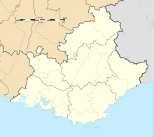
| Map | |||||||||||||||
  | |||||||||||||||
| Runways | |||||||||||||||
| |||||||||||||||
| Statistics (2018) | |||||||||||||||
| |||||||||||||||
| Source: AIP France, Aeroport.fr | |||||||||||||||
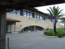
Toulon–Hyères Airport (French: Aéroport de Toulon – Hyères, IATA: TLN, ICAO: LFTH) is an airport serving Toulon and Hyeres The airport is located 3 kilometres (2 mi) southeast of Hyères, and 19 kilometres (12 mi) east of Toulon. It is also known as Hyères Le Palyvestre Airport. The airport opened in 1966.
Facilities
The airport resides at an elevation of 13 feet (4 m) above mean sea level. It has two paved runways: 05/23 measures 2,120 by 45 metres (6,955 ft × 148 ft) and 13/31 is 1,902 by 46 metres (6,240 ft × 151 ft).
Military use
This airport is shared with the French Naval Aviation (Aéronautique navale), as Hyeres Naval Air Base (la base d'aviation navale d'Hyères). Several squadrons of helicopters and fixed-wing aircraft are based on the south-western side of the airport.
Airlines and destinations
The following airlines operate regular scheduled and charter flights at Toulon–Hyères Airport:
| Airlines | Destinations |
|---|---|
| Air Corsica | Seasonal: Ajaccio, Bastia, Figari |
| easyJet | Seasonal: Bordeaux, Paris–Charles de Gaulle |
| Luxair | Seasonal: Luxembourg |
| Transavia | Algiers, Brest, Nantes, Paris–Orly Seasonal: Rotterdam/The Hague |
Statistics
| Graphs are unavailable due to technical issues. Updates on reimplementing the Graph extension, which will be known as the Chart extension, can be found on Phabricator and on MediaWiki.org. |
References
- ^ LFTH – HYÈRES LE PALYVESTRE. AIP from French Service d'information aéronautique, effective 26 December 2024.
- "Résultats d'activité des aéroports français 2018" (PDF). aeroport.fr. Retrieved 31 August 2019.
- "IATA Location Code Search (TLN – City: Toulon/Hyeres, Airport: La Palyvestre)". International Air Transport Association. Retrieved 22 December 2012.
- "Distance and heading from Toulon (43°08'00"N 05°55'00"E) to LFTH (43°05'50"N 06°08'46"E)". Great Circle Mapper. 22 December 2012.
- Hyères#Transportation
- "Air Corsica NS22 Network Additions — AeroRoutes". Aeroroutes.com. 22 April 2022. Retrieved 7 May 2022.
- "Luxair". luxair.lu. Retrieved 13 June 2021.
- Olivier, Nicolas; Izel, France Bleu Breizh (2 February 2021). "La compagnie aérienne Transavia va ouvrir 4 nouvelles lignes au départ de Brest". Francebleu.fr (in French). Retrieved 13 June 2021.
- "Where do you want to go?". Transavia. Retrieved 13 June 2021.
External links
- Toulon–Hyères Airport (official site) (in English)
- Aéroport de Toulon – Hyères (Union des Aéroports Français) (in French)
- Aeronautical chart and airport information for LFTH at SkyVector
- Current weather for LFTH at NOAA/NWS
- Accident history for TLN at Aviation Safety Network